Saturday, April 9, 2011

High Sierra: Laurel Mountain - The Pinner Chute

Pic of pic from Sierra BC skiing guide
Day three in the Sierra dawned sunny and calm in spite of a forecast that predicted winds gusting up to 85 mph.   We had planned a potential link up in the Convict Lake region, but once started, felt lazy and content with our week thus far.

The objective for the day was the Pinner Chute on Laurel Mountain.  This couloir is roughly 4000 ft of rock lined, moderate worry free fun in an area that reminds me of the Hogum Fork area (on a slightly larger scale) back home.
The impressive Mount Morrison, viewed from across Convict Lake
 We opted for that silly Teton style approach in our ski boots.  It really wasn't too bad as we were skinning just on the other side of the lake.
Going for it Teton style and IN style wearing tights.  Laurel Mountain in background.


JD putting a skinner in the Pinner
During the climb, the Sierra sun was blazing and we shed down to t shirts.  Where was the nasty weather?
On the summit ridge 

JD finding the entrance to the Pinner 
More JD

The upper sections had corned up nicely

Lower down, it was 65 degrees and getting sloppy
 Sunny skis and warm temps mean that skiing and swimming go together.
Convict Lake
Done early, we contemplated staying in the region for another day but the forecast was arguing against that.  We felt a little sheepish about driving home under sunny skies.  But, as we left, large plumes were visible on the high peaks, indicating the winds were picking up.  I would love to have stayed a while longer to explore some of the other amazing lines the region has to offer, but our decision was confirmed the next day when the weather report read poor visibility, high winds, snow, and full on winter conditions.  

To me, the greater ranges of the world include the Alaska Range, the Himalaya, and now the Sierra Nevada.  After this quick trip, I have multiple potential projects brewing in the dark corners of my mind.  Spring road trip anyone?  

Friday, April 8, 2011

High Sierra: Mount Whitney Ski Descent

photo of a photo by C. Pondella
 After coming down off of Split Mtn, we kicked it at the trailhead for a while, enjoying the hot Sierra sun before heading back to Bishop for some nasty Chinese food (anything with rice will always be the food of choice).  From there, we rolled down 395 to Lone Pine, took the Whitney Portal road, drove around the "road closed" signs, and made it to less than a mile from the trailhead before getting shut down by snow.  We packed quickly and were asleep (me in the car and JD outside on the ground where he belongs) by 9:30.


We got a semi early start and were hiking by 6:00 am.  Again, the alpenglow was unreal (sorry no pics), and within a couple hours, we had passed both boy scout lakes, catching stunning views of Mount Whitney and the Keeler Needle.

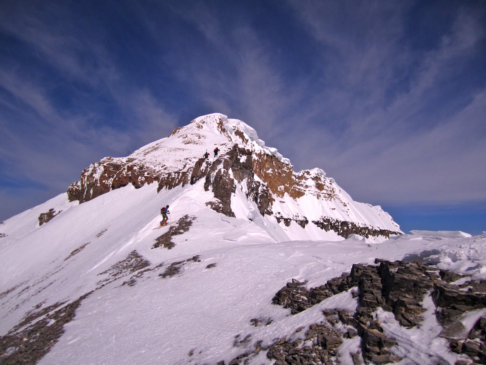
Looking for the highest point in the lower 48

 We skinned to the base of the Mountaineer's Route, where an army of mountaineers had put in a mess of tracks up the gut.  Sun on our backs, we hiked up the couloir to the notch we were bumped into a roped party heading up the first couloir immediately to the south.  Giving them space, we traversed over to the 2nd couloir that accesses the summit plateau, and a few minutes later were talus hopping in our boots to the summit.
Booting up the 2nd Couloir.  Mount Russell in the background. (photo by JD)

Nerds in tights on the summit
 On the summit, we bumped into a couple friendly guys with skis.  We chatted for a while, shared some food, and took turns snapping shots of each other before JD and I decided to take off and tempt our fate on the steep north facing slope above the mountaineer's route.

We downclimbed the first few feet to get established, donned skis, and made cautious turns on the 45-50 degree slope to where we could traverse back to the notch.  Luckily the snow was chalky smooth.  We did note a few lurking rocks on the way up and were able to avoid them on the descent.
Skiing the "2nd" couloir off Whitney's North Face (photo by JD)

Making cautious turns on firm 45 degree snow above serious cliffs (photo by JD)
 Back at the notch, we were psyched to open it up a little.  Below is a pic of JD doing just that.
JD working his edges
 The army of mountaineers had done a good job trashing the middle to the chute so we kept to the sides looking for undisturbed corn.
Getting into the meat of the Mountaineer's Route (photo by JD)

Crusty/slush or frozen boot track?

Corn feast (photo by JD)

Forgot our rock gear this time. (photo by JD)

JD figured out where he just came from
Down from the route, we took our skis off and lounged on some rocks near Iceberg Lake.  We decided to wait for the fellas we met on the summit to see if they'd like to join us for a jaunt up a nearby couloir.  The expected 5 minute wait turned into an hour and we thought something bad may have happened.  Turned out something bad did happen.

While making his first or second turn on the upper North Face, JA somehow double ejected from his skis after possibly hitting a rock.  He began to cartwheel down the 50 degree slope, got banged up on some rocks, and picked up speed heading for a huge cliff band.  His ride lasted for 150-200 feet before he was able to heed his partners screams to STOP by digging in his toes and arresting just 30 feet or so above the cliffs.  In the process, one ski went over the edge, while his partner, DA, climbed back up and retrieved the other. Surely shaken, the two made their way slowly down to the lake, where we found out what had occurred.

Here, we congratulated our new buddy on still being alive and offered to go over the Whitney/Russell Col to retrieve his ski.  He offered a monetary reward that we instantly rejected, saying that it would be our pleasure to go explore that drainage looking for treasure.

We traversed around until under the North Face and identified the chute we had descended before traversing to the notch at the top of the Mountaineer's Route.  In an effort to be efficient, I skied down the drainage and JD climbed toward the cliff band.  My search was fruitless, so I climbed back up trying to rejoin JD.  As he approached the cliffs, I yelled up, asking if he could see anything.  His immediate reply was, "NOTHING!"  Five seconds later he began to squeal with joy as he spotted the errant ski, accessible, propped against some rocks.  My own squeals poured forth as we were both psyched that JA was not only alive, but had all his gear and would be able to ski out.

"2nd Couloir" on the North Face.  Our descent traversed looker's left to meet up with the Mountaineer's Route.  The errant ski was found at the base of the large cliff band midway down.  If one looks closely, JA's claw marks are visible, stopping just shy of the rocks.

The three ski wonder
We made the quick traverse back over the col and down to Iceberg Lake where we met up with DA, and then took off to catch up to JA, who was getting a head start out in case his ski was unretrievable. The man was stoked to see his ski and to get back on two feet, somewhat salvaging his descent.

While I'm sure the events kept replaying in our new buddy's mind, the mood became lighthearted as we skied fun corn almost back to the car.  A friend once said that in the mountains the rules are to come home alive, friends, and successful - in that order.  Done, done, and done.

Day II in the books.  Part III coming...


Thursday, April 7, 2011

High Sierra: Split Mountain via Split Couloir

Photo of photo by C. Pondella
Brother JD and I just returned from a smash and grab 4 day trip to the high Sierra.  We had been following the weather and it looked like it was time to attempt some big lines.  This TR will be the first of a three part series.  First on the agenda was the extremely aesthetic Split Couloir on the 14er, Split Mountain.  The drive was uneventful until we tried to make the approach to the trailhead on a long 4x4 road, riddled with cunning dead ends.  After filling in some ruts with our shovels and consulting the world wide interweb, we made it to the Red Lake TH around dark.


Surprisingly, there was another party camped out, but they were planning on the SE Face of Split.   Up at 4:30, we "racked up," ready to climb ice/rock/snow, and to have a full on ski adventure.  Again, to our surprise, there was another party that had snuck in during the night, that was leaving at the same time.  A quick conversation revealed they had the same objective in mind.
CP with ski crampons, on fire in the Sierra alpenglow
Glow Tree
 They were super cool guys and offered to point us in the right direction.  Turns out one was Squaw native, John Morrison, and the other was Christian Pondella, from Mammoth.  Both strong alpinists, we made the approach together to the base of the couloir while enjoying the rich morning alpenglow.

A couple hours and four thousand feet later, we pulled up to the crux of the climb - an icy headwall, guarding the entrance to the couloir.  Starting vertical, the ice flow eased off after 20-30 feet.


             The greatly foreshortened Split Couloir ascends to the notch between the South and North Summits
 The plan became for JD and I to place to booter to the summit while CP and JM rigged the anchor and for them to join us before making the descent.  John said he thought maybe less than 10 people ever have skied the Split Couloir and that very few if any had climbed and skied it.  Now, with it's inclusion in the book, 50 Classic Ski Descents in NA, those stats will quickly change.
Nearing the ice headwall
The ice flow was warm and straightforward.  Maybe AI 4, JD and I soloed the short 30-40 foot pitch. Now realizing that we had about two 60m ropes, a rack of pins, 8 screws, and a few cams too many, we finished off the easy ice section and left the gear to be retrieved on the way down.

Nearing the top of the ice headwall (photo by JD)
JD watching and taking pics of CP on lead


 A couple thousand feet later, we were standing at the notch between the two summits.  I think I have a new favorite range.

High Sierra from the notch on Split Mountain
A short climb leads to the higher North Summit, where we were amazed by the weather and the endless possibilities.


JD looking back toward the notch

 The skiing was marginal, with variable conditions most of the descent.  Pockets of softer drifts made some turns enjoyable.
JM giving a clinic on chute skiing (photo by JD)
CP with his smooth, easy style (photo by JD)

JD

Now in the shade, the surface was crusting up 
Low in the couloir (photo by JD)
 A couple hundred feet above the rappel, a group decision was made to down climb the low angle ice/snow patches rather than side step through.
Group down climb to the rappel (photo by JD)
 A single rappel was all that was needed to free ourselves from the couloir.
JD on rappel

 On the apron, I had a fleeting thought of heading up the St. Jean Couloir but with more to ski during the week and a lingering cold, gang skiing thousands of feet of California corn sounded more fun.
Where's JD?
We were told by the other guys that this year has been huge in the Sierra.  I feel like we pulled off a coup, finding the Split so filled in and making the descent with two local hard men.  On the way out, JD and I agreed that if we could tick the Split and Mount Whitney, the trip would be a huge success.

Installment II coming...

Friday, April 1, 2011

The Timp Traverse*

Chad, first time on Timp
After such a good day yesterday I had a feeling we'd be back on Timp again today.  Buddy Chad had never been on the Sleeping Maiden so we thought a good introduction would be to try and traverse the whole mountain.  Here's the story.

A 3:50 am wake up led to a sleepy drive to pick up Chad on the way down to Utah County.  Samurai Jared and brother JD met us down there at 5:00.  We had planned on starting across from Bridal Veil Falls and ascending a couloir that would take us to the main ~ 7 mile ridge.  Dark, unfamiliar, without a place to park, and staring a nasty bushwhack in the face, we chose to start from Canyon View Park in Provo Canyon instead.  Our initial ascent would be via a west facing couloir on the very south end of the mountain.  From there we planned on hitting every bump along the ridge that got in our way and once we ran out of mountain, ski the Cold Fusion Couloir off the north end of the mountain down to American Fork Canyon.  That's why there is an asterisk on the title.  A full traverse would travel the entire ridge.  In our defense, we did start very low in Provo Canyon and nearly traversed the whole mountain.  According to Jared's GPS, it was approximately 15 miles and nearly 10,000 vertical feet.


Avoiding the big cornices was the name of the game
 We were on dirt for about 3 miles before finally switching to skis.  The conditions were firm with a stout crust making the initial skinning fast and easy.  Once the angle steepened, skinning was a liability but the crust was in most places breakable while booting.  Those are about the only conditions where ski crampons seem useful.  And...I would have killed to have some.  Jared and Jason had the nice blue Dynafit ones and skinned along the summit ridge with ease.  Chad and I ended up post holing for miles.
JD and Jared pulling away en route to the main summit
 We skied a short descent from the South Summit and made the long traverse over to the Main Summit, finding fun terrain along the way.
Butt shot - Chad

Rock step en route to main summit

Chad post holing in the other's skin track

A million steps
  Jared and Jason, able to skin, beat us to the main summit by 10 minutes or more.  I guess they got a little bored.

?????????
 Skiing down from the main summit, a few cliff bands needed to be dealt with.  JD was in the lead and found his way down a steep little rocky traverse.  Jared watched in horror and decided that it wasn't worth it.  From that situation, I take it that JD is reckless.
Down climbing JD's reckless descent

The secret passage

Chad below the main summit

Jared and Chad tempting a cornice below Bomber Peak
 I've taken pictures from the North Summit before, but, now looking along the ridge the pics have different meaning.
Chad approaching the North Summit
 It wasn't until early afternoon and nearly at the end of the traverse that the snow softened enough to allow easy skinning.
The fellas ripping skins for the last time
 Ran out of mountain...
JD and Jared, out of mountain, looking for the Cold Fusion
 Everyone wants to ski the Cold Fusion Couloir.  I'd say that this wasn't the standard approach.
Chad, finding out he took the long way to the Cold Fusion
10 hours and numerous summits/sub peaks later, we ended up skiing right down to the road in AF Canyon near the Tibble Fork turn off.  From there, JD had to hitch hike up canyon to where little sister AD was awaiting with a 2 door Accord to shuttle 4 stinky guys and gear back to our cars.  Another great adventure right here in our back yard.  Next up is a trip to the Sierra.  Any ideas?