Friday, June 4, 2010

Volcano Tour 2010 Wrap Up

Our week in the Pacific Northwest was an overwhelming success in spite of the weather forecast that looked like: rain, rain, mostly sunny, rain, rain, rain, rain, rain.

A few quick stats:
  • 5 Ski Days
  • 35,000 vertical
  • 4 volcanos summited and skied (Adams, Rainier, Hood, Shasta)
  • 1 Thwarted Attempt on Mt. Baker due to nauseating whiteout conditions above 8,000'
  • 3,553 miles driven (with detour through Yosemite)
  • Surprisingly, only 3 meals at McDonald's
  • Eaten - one doughnut shaped like male genitalia from Voodoo Doughnuts in Portland
  • 1 sprained ankle
  • 3 stinky dudes

As posted previously, we managed Mt. Adams while all the other peaks were shrouded in clouds, and scored Rainier under splitter blue skies. I left SLC on May 21st and drove up to Portland where I picked up Jason and viking Lars who flew in from Indy and Denver respectively. We grabbed some groceries and drove out to the Adams' trail head which was conveniently located 5 miles from the real trail head due to lingering snow which kept the approach road closed. Sleeping at the roadside, we donned ski boots and were hiking "Teton Style" at 5 AM. Stupid. Anyway, 8,000 vertical later...

Lars finding his way back to the cloud deck


Sunday was a rest day as we drove up to Paradise on Rainier to secure permits and inquire about the weather/route conditions. We had planned on skiing the Emmon's Glacier, but the standard Ingraham Direct was "In" and had a much more convenient approach that still topped 9,000'. That night we ate at a sherpa restaurant, stayed at the Whittaker Bunk House, and then woke up at 2:00 AM. We were skinning from the car at 3:30 under clear skies and the thousands of vertical began ticking away.

Gorgeous morning


Looking back through Cadaver Gap toward Camp Muir, with Mt. Adams looming beyond
After a couple hours we began passing parties that had camped higher on the mountain. They were roped up as teams of 2-5+, hiking as slow as ants, unenlightened to the thought of snow travel eased by skis.

A look at the Ingraham Glacier with the route weaving through well bridged crevasses

We stood on the summit by 10 AM and were psyched to begin a 9,000' descent back to the car. The snow was variable but pockets of powder were still found up high. It's rare that one gets to feel like an absolute hero, but as we flew past the roped parties, mouths agape, we caught phrases here and there like, "BAD ASS!" Yeah, even though around most parts, we're nothing special, it felt pretty good to have our day in the sun.

JD on the Ingraham...about 8,000 ft to go


Viking Lars


Near the bottom of the Muir Snowfield, I was surprised as I went of a ~8 ft bank of snow and was suddenly air born. I thought I could control the landing but was immediately air born again as the embankment rolled off again steeply for another 8-10 feet. I bailed and summersaulted down to a stop just above a small rock outcropping. Happily unhurt, I yelled at the others not to follow and exchanged a coy glance with some rangers who were working on a nearby facility.

Thinking all was well I brushed off and tried to ski and immediately wrecked again. I quickly found out that the peg on my boot that locks the buckle into ski mode had completely snapped off, confirming in my mind that D.N.As are as others have reported, a bit fragile.
Back at the car before noon we immediately turned our thoughts toward Mt. Baker and pointed the car north. We drove up to the standard trailhead for the Easton Glacier and camped in a dirt pullout, setting up just as the rain came to a stop. Baker is another relatively big day at 7,500' and we were feeling a little less than motivated as we sat on the tarp at 5:30 AM cooking breakfast, listening to music from the car, and laughing at Lars' puffy face, swollen from sleeping head down slope with out a pillow.
The clouds were low lying but glimpses of the sun were caught intermittently so we were off again. Baker sits among the North Cascades which are absolutely stunning and offer an apparent eternity of steep skiing.


Around 8,000 ft, we hit the clouds and everything turned into a dangerous whiteout. Unable to discern up from down and only having a vague sense of where they summit lay, we did the only reasonable thing...fashioned a big pit to wait it out.


Unfortunately, the storm intensified and as we were unprepared, lacking wands and a map, we turned tail cursing Mt. Baker and the Pacific NW rain.

Still having fun though


A bit bummed about having our streak ruined, we headed back south, contemplating some interesting lines in the Tatoosh Range which while on Rainier look like mole hills but are super rugged and worthy little peaks.

Lane Peak with multiple striking couloirs. (Photo stolen from summitpost.org)

The rain, however, continued through the next day and the Tatoosh were not to be. So we went to Portland to stay with a friend and bouldered at a local gym where Jason rolled his ankle on the first problem of the day. $12 for a sprained ankle...good deal? Thinking flexy F1s would be more or less like an ankle brace, he sucked it up for the next day's objective, Mt. Hood.

On the drive up to Timberline Lodge, we were sure we'd get turned back again. Even the lifts were obscured by clouds and none of us had been on the mountain previously. Except this time we brought a couple secret weapons: a map, and about 300 wands (construction flags available at Home Depot, 100 for $7). We followed the lift line like braille and Jason gave us a 1 in 15 chance of making the summit. He'd be a terrible forecaster. After a snack, the clouds parted and the summit showed herself, completely coated in rime ice. We made a mad dash, dropping wands every 40-50 meters in case the ever threatening clouds moved back in.


A quick skin up the Hog's Back,


And a booter to the Pearly Gates,

led to some climbing through moderately steep rime ice and snow
and we found ourselves on the summit, again engulfed by clouds but thrilled at another summit and 5,400' of fun at our ski tips. On the way down, the clouds again parted and...

Blessed again.

We felt we'd stolen another peak from the weather gods, who must have had enough with our foolish/bold attempts because the next couple days the forecast (from the real forecasters, not Jason) was more rain...heavy rain. And, to complicate matters, the permits for Mt. St. Helens were sold out until the weekend. Ridiculous. Furthermore, the trail head for St. Helens starts at 2,700 ft or so, making the first few thousand ft of the climb on dirt and in the rain.

A meeting of the minds and a 100% guarantee (from Jason) that we'd have success prompted us to jump back in the car and drive 6 hrs south to Mt. Shasta. There was real appeal to this new plan because it would "guarantee" that we'd tag the 4 highest volcanoes giving the trip a nicer symmetry.

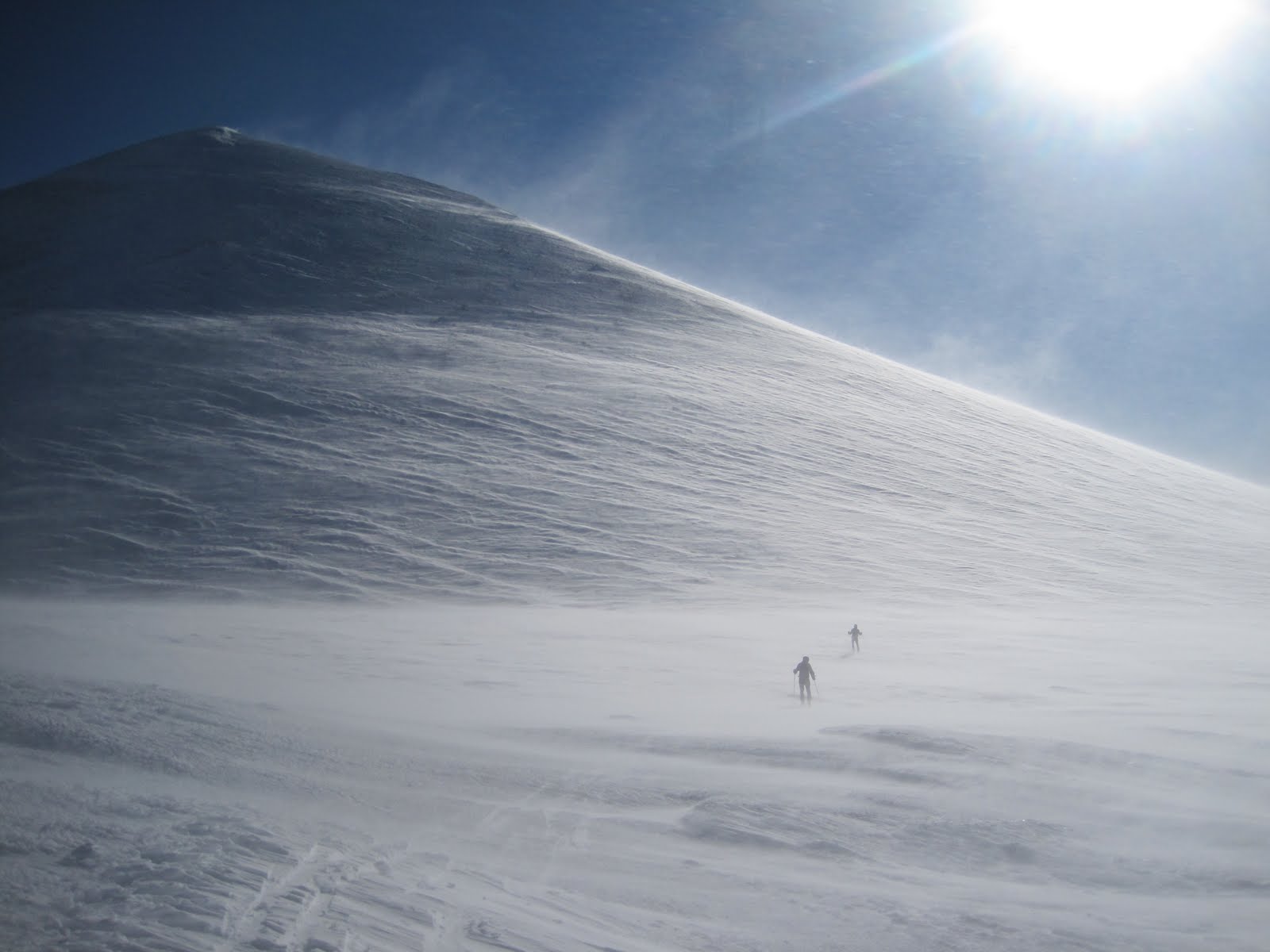
A 3:30 start put us in position to blow by all those on foot while still relatively low on the mountain. Again, we were the only ones on skis, and all the traditional "mountaineers" who had camped 3500 feet up, appeared utterly defeated as they stood knee deep in the new powder and watched us climb past. From that point on, we had the whole mountain to ourselves.

The morning was beautiful only in appearance. Savage winds scoured the mountain and nearly knocked us off our feet repeatedly. It was hardshells, zipped to the top, hoods on, type of weather.

Shasta Shadow

Skinning toward the Heart. Our descent wound through some chutes in the center of the photo


Above Heart and heading for Misery Hill, just below the summit plateau. Winds WHIPPING (Video to come)
I didn't even pull out my camera on the summit because the wind was intolerable. Once in the lower chutes to the "left of Heart," we found some protection and undisturbed prime volcano powder.


JD

Jason's guarantee fulfilled

Victory

Volcano Tour...Over
Next up...Yosemite Valley

Tuesday, May 25, 2010

Volcano Tour 2010

Jason, Lars, and I are up in the Pacific NW on our quest to summit and ski 5 of the major volcanic peaks. They are in attempted order: Mount Adams, Mount Rainier, Mount Baker, Mount Hood, and Mount St. Helens.

We have 7 days and a marginal weather forecast so we'll be going for them all car-to-car in a day and then moving camp to the next trailhead. We're a few days in now and...

Mount Adams: Check


Mount Rainier: Check

14,411 feet high

Three more to go. Trip reports and pics to come...

Sunday, May 16, 2010

Southern Utah Sampler: Ski/Bike/Climb


I picked up "little brother" Sam early Friday morning and loaded up skis, bikes, and climbing gear for a trip to Southern Utah. We only had a couple days, but decided we should try and make the most of our time. Our first stop was the ultra scenic Indian Creek pictured above. We met uncle Roman and Sam's brother Aaron and headed to the Battle of the Bulge Buttress where we all thrashed about on some of the easier but classic routes like "Think Pink" and the "Cave Route."

Think Pink, 5.11-

Cave Route, 5.10+

Here I am, PSYCHED

for Sam who is in the process of "honoring" his first Indian Creek 5.10

Some late afternoon rain sent us scurrying back to Moab for some Micky D's, where we bid farewell to Roman and Aaron. Sam and I had designs to ski something in the La Sals, but being unfamiliar with the area, just blindly drove up and up to a trailhead at 9,200', where we camped, conveniently right at the snow line. A topo at the trailhead informed us that Mt. Mellethin, a 12,700' peak and second highest in the La Sals, was an easy skin/ridge traverse from the car.

What's wrong with this picture?
The women's ski boots, the tights, the board shorts, or snow in the middle of the desert?

Mount MellethinOur line descends from the top, cuts through the middle of the upper cliff bands and takes the chute on the looker's left.

On the way, we topped out Peak 12,271 making good use of the summer trail.

A quick ski off Peak 12,271 and a short booter up the south rigde caused Sam to get a little confused, thinking he was in the desert The La Sals are a beautiful range with an apparent abundance of big lines.

Sam on the summit, still hot

Awesome corn skiing on what turned out to be a pretty mellow line brought us back to the car.

A quick bite at Subway and it was off for round two

The stellar North Chimmney was the route of choice

Summit shot from Castleton Tower

We ran down the trail and jumped in the car to try and bang out phase 3 of the day before dark Riding the Slickrock Trail seconds before laying my bike down. I am a terrible mountain biker. The ride was by far the scariest part of the day for me.

We raced the sun
and made it out just before dark.

Thursday, May 13, 2010

NE Couloir, Lone Peak...Finally

After so much talking and lusting after this line, I finally got the chance to ski it today, May 13th, in prime powdery conditions. I've been spending a bunch of time running, climbing, and vacationing with Jessie so there hasn't been much time to ski lately. I even did my first bike race last night at the DMV Crit. I guess after the WURLOS I had had my fill for a bit. But, I was starting to think I should make the most of my time off and get in some skiing to prepare for the Volcano Tour 2010 (more to come on that in late May). I called Adam who called a friend of a friend, and we decided we'd head up Bell's around 6:30 AM. Why Bell's? I feel like I've hiked up and down that enough this year. We wore running shoes and ditched them in a tree at the snow line a couple miles up. I wasn't feeling all that strong, likely as a result of too much gluttony at sea level last week and the most time off snow I've had all winter. A couple sweaty hours later we found ourselves at the base of Lone Peak's impressive NE face wondering which line was the NE Couloir. From the bottom, there are a number of cliff bands and the chute proper isn't visible. We guessed right and traversed in above the cliffs ready to boot our way to the summit.

The guys switching to booting as we find the sneak entrance

Beautiful midwinter day in May. Huh, the peaks in the distance look all too familiar.

The snow was still a heavy powder that was a chore to boot up.

Near the top looking down with the boys plugging along.

We were able to boot directly to the summit with the last 10 feet being a bit of a scramble.

Summit shots


I chose to down climb the top few feet as did Adam, but Zack aired off the summit block onto the steep (50 degrees?) upper slopes. A little jaunt skier's left from the summit brought us to the top of the chute.

Adam, from just below the summit

Zack

We skied one at a time with Zack and Adam making it look easy. It was cool to watch their sluff pour down the chute and over the cliffs at the bottom. While I was working skier's right to avoid the lower cliff band, Zack decided to take the direct route. He said, "well, if I go fast enough, I'll clear anything." Good advice eh? He landed the jump in style.

Even though we're in the midst of a schizophrenic spring, the snowpack is super deep up high. There are a few more lines I'd like to get in before I turn my attention full time else where, but today felt like a capstone to an awesome winter.

Wednesday, May 5, 2010

New American 10K Record

Last weekend at the Payton Jordan Invitational at Stanford, Chris Solinsky of Nike and the Oregon Track Club set the new American record in the 10,000 meters. He is the first runner of non African descent to break the 27 minute barrier and the fourth fastest ever debut at the distance. He is also by far the biggest runner to go under 27 minutes, checking in at 6'1" and 164 lbs. Prior to the race, there was a lot of hype about Galen Rupp making an attempt at the American record with Nike organizing pacemakers for his bid. Rupp had a great ballsy race and pushed the pace through the 6-9K range after the rabbits dropped out. It never occurred to Rupp or his coach Salazar that they could setting up Solinsky for the win. Here's the video of the whole race. It gets really exciting about 25 minutes in.

New American 10K record

With some plans of our own, Jessie and I have been putting in some nice runs in the Whitefish, MT area. 6 easy on Mon and 13 on Tues. The weather hasn't been good for much of anything else.

Dreary Montana


Beautiful Montana

Another easy run today in Glacier National Park and then next up...Bismarck, ND

Tuesday, May 4, 2010

Prodigal Sun/Gooseberry Mesa

The climbing allure of Zion National Park has quietly been tempting me for the last three years. A friend took me down there once to teach me how to aid climb, but we only ended up "aid cragging" at the base of some of the bigger lines. Since that day, I've climbed bigger stuff in Yosemite and elsewhere, always bypassing Zion because it was too hot, too local, too whatever. Well, with less than inspiring weather everywhere except Zion, I conned trusty Sam into coming down to chase down the line, Prodigal Sun, on Angel's Landing.

Angel's Landing is a striking formation that extends from the canyon walls like a peninsula in the sky and is a major hiking destination for many park visitors. The hike itself is a proud scramble that occasionally turns fatal as the exposure is extreme and the terrain rugged. Maybe 10 years ago, I stood on the summit oblivious to the real climbing possibilities.


Prodigal Sun is predominately an aid line that ascends the right side of the above picture. It is continuously steep with a smattering of tricky placements and hook moves. I had planned on leading the majority of the climb and having Sam dispatch the C1 pitches and the last free pitch. But first, we had to cross the river, which was flowing at 300+ cfs. The flow wasn't difficult, maybe just above the knees (mid thigh for Sam), but the water was ICY cold. Painfully cold. We crossed without mishap, pantless, but with puffy jackets and beanies.

I lost the trail and mud soloed a small cliff band, where I could look down and point Sam in the right direction. He skirted around, and soon we found the base of the climb.

Looking up canyon toward Moonlight Buttress

A look East at the Organ and the Virgin River

The route starts with a good ole fashioned bolt/pin ladder

Sam jugging in the backgroundSam had practiced ascending a fixed line the day before in my garage. It's a little different doing it for a thousand feet straight up. But, like all things, he picked it up quickly and made easy work of cleaning the route.

Somewhere near this point, after seeing the cumbersome engineering that is aiding and hearing me mutter something about breaking my ankles while above tipped out cams, hooks, and poorly placed tricams, Sam decided he'd be better off jugging the rest of the route and graciously let me lead the whole thing.

The jugging machine

Up Canyon, Moonlight and Spaceshot visible

Cerberus Gendarme

Near the top of the route We just finished in the daylight then hiked out to the Grotto where we caught the second to last bus back to the visitor's center. A short drive led us to Hurricane where a McDonald's victory dinner awaited.

That night, we drove out to Gooseberry Mesa and tried to sleep through a wind storm and even a little snow. Actually, I slept pretty well in the Subaru.

Sam still hiding in the tent.

We went on a mellow short ride with Sam coaching me the whole time.

Sam

Sam near the "point"

Beautiful view toward Zion

And lastly, my new love affair

Jessie and I are up at Whitefish Lake in Montana right now enjoying a little sleet and snow on our vacation. Too bad I didn't bring my skis.